- New Rare Art
- Artist
- Andy Warhol (14)
- Banksy (81)
- Beejoir (8)
- Billy Childish (9)
- Damien Hirst (16)
- David Hockney (7)
- David Shepherd (8)
- Death Nyc (28)
- Emek (8)
- Jj Adams (16)
- Kaws (14)
- Keith Haring (9)
- Mike Shenton (12)
- Mr. Brainwash (17)
- Pure Evil (24)
- Shag (josh Agle) (9)
- Shepard Fairey (33)
- Stik (11)
- Tracey Emin (17)
- William Klein (6)
- Other (1785)
- Format
- Material
- Style
- Abstract (28)
- Americana (9)
- Art Deco (26)
- Art Nouveau (9)
- Contemporary Art (65)
- Country (9)
- Crossbody (9)
- Graffiti Art (38)
- Illustration Art (18)
- Modern (28)
- Modernism (12)
- Outsider Art (5)
- Pop Art (105)
- Portraiture (10)
- Realism (24)
- Silk Screen Poster (6)
- Sneaker (16)
- Surrealism (10)
- Urban Art (55)
- Vintage (16)
- Other (1634)
- Type
- Unit Of Sale
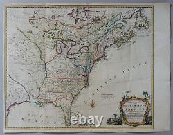
A new and accurate map of the British Dominions in America-Kitchin 1766-RARE


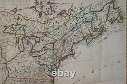
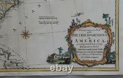
A New and Accurate Map of the British Dominions in America, according to the Treaty of 1763.. (Die Ostküste Nordamerikas von Neufundland bis Florida - Britische Gebiete). Es handelt sich hierbei um eine seltene originale, kolorierte Kupferstich-Landkarte der britischen Gebiete an der Ostküste Nordamerikas von Thomas Kitchin aus dem Jahr 1766.
Titel: A New and Accurate Map of the British Dominions in America, according to the Treaty of 1763; Divided into the several Provinces and Jurisdictions. Ort: Die Ostküste Nordamerikas von Neufundland bis Florida - Britische Gebiete.
Kartograph: Thomas Kitchin (1719 - 1784). Größe des Plattenbereichs: 52 x 62 cm. Zustand (Perfekt/ Sehr gut/ Gut/ Ordentlich/ Mäßig/ Schlecht): In gutem Erhaltungszustand. Bemerkungen: Diese seltene, bedeutende Landkarte der Ostküste Nordamerikas wurde im Jahr 1766 von Thomas Kitchin verlegt. Die Karte ist sehr detailliert ausgeführt und verzeichnet u. Diverse Minen, Forts und Indianergebiete. Eine dekorative Titelkartusche bereichert den Kartenbereich. A good example of this important, rare and very detailed map of the Eastcoast of Northamerica by Thomas Kitchin (1719 - 1784), printed in 1766. The map is extremely scarce.It shows the British Dominions in Northamerica just after the end of the Seven Year's War and the Pontiac's War in 1766. The map depicts the area with high attention to detail.
It shows many mines, early Forts and Indian Tribal regions. A decorative title cartouche enriches the map further. This is an unrecorded example, which does not include a printer's attribution at the bottom of the map. This genuine copper engraved map measures 52 x 62 cm (platesize) and is in good condition.
If you have any questions, please don't hesitate to ask. Für die Suchmaschine: view map engraving switzerland suisse gravure carte helvetia. Auf Wunsch stellen wir Ihnen gerne ein kostenfreies Echtheitszertifikat aus. If you wish, we will gladly provide a certificate of authenticity free of charge. This item is in the category "Antiquitäten & Kunst\Kunst\Kunstdrucke".
The seller is "kunstantiquariat-online-2" and is located in this country: DE. This item can be shipped to North, South, or Latin America, all countries in Europe, all countries in continental Asia, Australia.
- Jahr: 1766
- Zeitraum: Vor 1800
- Thema: Länder, Landkarten, Landschaften
- Kontinent: Nordamerika
- Format: Querformat
- Motiv: Landkarte
- Alter/Originalität: Original vor 1800
- Original/Reproduktion: Original der Zeit
- Kunststil: Barock
- Eigenschaften: Ungerahmt
- Anzahltyp: Einzelwerk
- Technik: Kupferstich
- Drucktyp: Handgefertigt
- Verkäufertyp: Kunsthändler
- Land: USA
- Originalität: Unikat Handgefertigt Original
- Marke: Markenlos
- Produktart: Print

